Earth's layers and the engine beneath
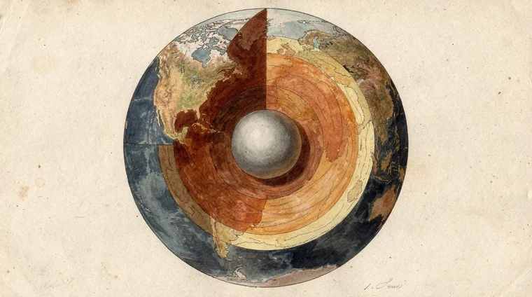
To understand what is plate tectonics, it helps to understand the planet's structure. Earth is built in layers, like an onion.
The outermost layer — the crust — is what we walk on. Continental crust is 30–70 km thick, while oceanic crust (the seafloor) is only 5–10 km thick. Below the crust lies the mantle, a layer of solid rock that extends 2,900 km deep. Despite being solid, mantle rock flows like putty over millions of years, driven by intense heat from Earth's interior.
Deeper still is the outer core — liquid iron and nickel at around 5,000°C. At the very centre sits the inner core, a solid iron ball. Scientists have mapped this invisible interior using seismic waves from earthquakes, which travel at different speeds through different materials. The liquid outer core was discovered in 1906. The solid inner core was confirmed by Danish seismologist Inge Lehmann in 1936.
We have never drilled anywhere near this deep. The deepest borehole ever made — the Kola Superdeep Borehole in Russia — reached just 12 km before engineers gave up. Everything deeper is known only from seismic evidence.
It is this slow churning of the mantle — called mantle convection — that drives the plates above it. Hot mantle rock rises, spreads sideways, cools, and sinks back down, dragging the crustal plates with it. This is the engine behind plate tectonics.
These structures connect to how the solar system formed — part of the same origin story of planetary formation.
From continental drift to plate tectonics
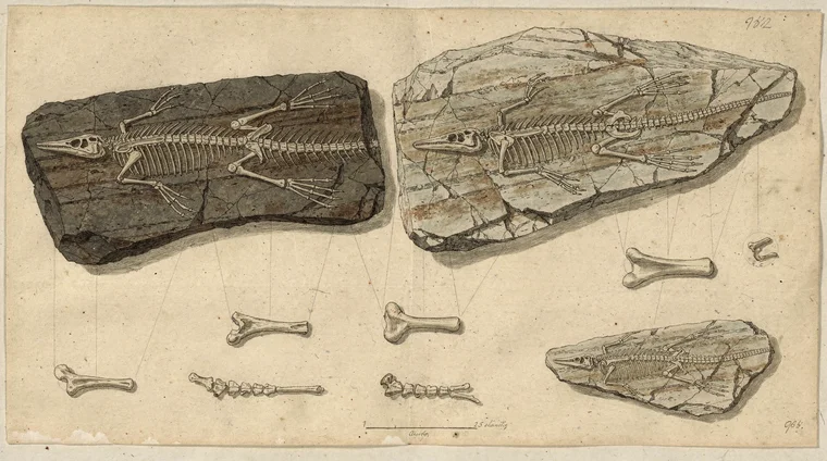
The idea that continents move was first proposed in 1912 by German meteorologist Alfred Wegener. He noticed that the eastern coast of South America and the western coast of Africa fit together like puzzle pieces. He found identical fossils on both continents — including Mesosaurus, a freshwater reptile. Mountain ranges appeared to continue from one side of the Atlantic to the other.
Wegener proposed that all the continents had once been joined in a single supercontinent he called Pangaea, which had broken apart over millions of years. The scientific establishment rejected him almost completely. No one could identify a mechanism that could possibly move entire continents. Wegener died in 1930, his theory largely dismissed.
The mechanism emerged in the 1960s, when oceanographers discovered seafloor spreading. Geologist Harry Hess proposed that molten rock rises continuously at underwater mountain chains called mid-ocean ridges. This pushes the seafloor outward on both sides and drives the continents apart. The Atlantic Ocean is widening at about 2.5 cm per year — roughly the rate a fingernail grows. The Pacific, where crust is sinking back into the mantle, is slowly shrinking.
The evidence that clinched the theory came from the ocean floor itself. As molten rock cools at mid-ocean ridges, iron minerals lock in the direction of Earth's magnetic field. Earth's magnetic field reverses direction every few hundred thousand years. These reversals are recorded as alternating magnetic stripes parallel to the ridge — a living tape recording of seafloor spreading, precisely as Hess predicted.
Wegener was vindicated. His insight was correct; he simply lacked the evidence that ocean exploration later revealed. USGS Historical Perspective documents this scientific revolution in full.
Read the full history in the USGS publication This Dynamic Earth, including the seafloor spreading evidence that vindicated Wegener.
Did you know?
-
Earth's crust is divided into about 15 major tectonic plates and several smaller ones. Continental crust is 30–70 km thick; oceanic crust is only 5–10 km thick. The Kola Superdeep Borehole in Russia — the deepest hole ever drilled — reached just 12 km before being abandoned in 1992.
USGS — Earth's Interior -
The Atlantic Ocean widens at about 2.5 cm per year as new seafloor forms at the Mid-Atlantic Ridge. Iceland sits directly on this ridge and is one of the few places on Earth where a mid-ocean ridge rises above sea level, making it a natural laboratory for studying seafloor spreading.
USGS — Developing the Theory -
The 2011 Tohoku earthquake in Japan — magnitude 9.1, the most powerful ever recorded in Japan — shifted the seafloor by up to 50 metres at the rupture zone and generated a tsunami that killed approximately 20,000 people. It occurred at a convergent plate boundary where the Pacific Plate subducts beneath Japan.
USGS — Understanding Plate Boundaries -
The Himalayas contain marine fossils near their summit — remnants of the Tethys Sea floor that was lifted when the Indian subcontinent collided with Asia approximately 50 million years ago. India is still moving northward at about 5 cm per year, and Mount Everest is still growing.
USGS — The Himalayas
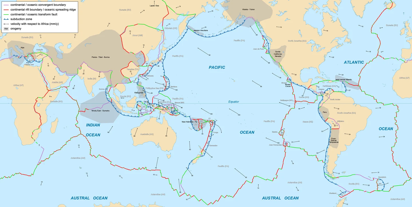
Plate boundaries: where the action happens
The boundaries between tectonic plates are where Earth is most geologically active. There are three types.
Divergent boundaries
At divergent boundaries, plates move apart and magma wells up to fill the gap, creating new crust. Iceland sits on the Mid-Atlantic Ridge, a divergent boundary, which is why it has so many volcanoes and geysers. The East African Rift Valley is a divergent boundary on land — Africa is slowly splitting in two.
Convergent boundaries
At convergent boundaries, plates collide. If one is oceanic and one continental, the denser oceanic plate sinks beneath the other in a process called subduction. As the sinking plate melts and releases water, it triggers volcanic eruptions above. This is why Japan, the Philippines, and the Andes of South America all have chains of volcanoes.
When two continental plates collide, neither sinks easily — both are too light. Instead, the crust crumples and thickens, building mountain ranges. The Himalayas formed this way when the Indian subcontinent crashed into Asia roughly 50 million years ago. India is still moving northward at 5 cm per year, and Everest is still growing.
The Ring of Fire marks a horseshoe-shaped chain of subduction zones around the Pacific. It is home to about 75% of the world's active volcanoes and the majority of major earthquakes.
Transform boundaries
At transform boundaries, plates slide horizontally past each other. The famous San Andreas Fault in California is a transform boundary between the North American Plate and the Pacific Plate. The two sides grind past each other, building up stress that is released as earthquakes.
California, Japan, and Indonesia experience frequent earthquakes and eruptions because of their location at plate boundaries. The For parents guide includes suggestions for discussing natural disasters.
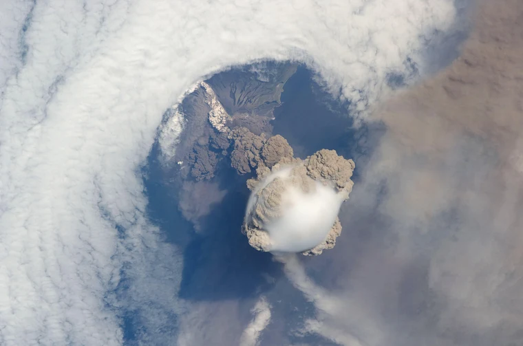
Sarychev Peak volcano erupting in June 2009, photographed from the International Space Station. The volcano sits on the Kuril Islands above a subduction zone in the Pacific Ring of Fire, where the Pacific Plate sinks beneath the Okhotsk Plate.. Image: NASA (ISS020-E-009048), via Wikimedia Commons (Public domain)
Mountains, rocks, and deep time
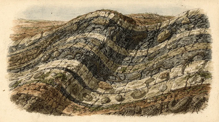
Plate tectonics is inseparable from the story of rocks and mountains. When continental plates collide, layers of seafloor sediment are folded and pushed upward. These layers sometimes contain the fossils of marine creatures. The marine fossils near the Himalayan summit are not an anomaly. They are direct evidence of how dramatically plate collisions can lift ocean floors into the sky.
Plate tectonics also drives the rock cycle — the continuous process by which rocks transform from one type into another.
- Igneous rock forms when magma cools — either underground (like granite) or at the surface during a volcanic eruption (like basalt).
- Sedimentary rock forms when igneous or other rocks are broken down by weathering, carried by rivers to the sea, and slowly compressed into layers — like sandstone and limestone.
- Metamorphic rock forms when existing rock is buried deep in the crust and transformed by heat and pressure — like marble, which is metamorphosed limestone.
At subduction zones, old oceanic crust sinks back into the mantle and eventually melts, completing the cycle. Nothing in the rock cycle is wasted; matter is recycled continuously over billions of years.
This perspective is called deep time. It holds that processes invisible on a human timescale have operated for hundreds of millions of years — one of the most important concepts in Earth science. Understanding plate tectonics means accepting that the world is not static. It has always been in motion, and will continue to change long after us.
Students interested in climate and weather will find that tectonic processes shape long-term climate — through volcanic emissions and mountain ranges that redirect winds and precipitation.
Frequently asked questions
- How fast do tectonic plates move?
- Tectonic plates move at speeds of 1–10 cm per year — roughly the rate your fingernails grow. The fastest-moving plate is the Tonga Plate in the Pacific, moving at about 24 cm per year. Over millions of years, these small movements add up: the Atlantic has widened by thousands of kilometres since the breakup of Pangaea.
- Can we predict earthquakes using plate tectonics?
- Plate tectonics tells us where earthquakes are most likely — at plate boundaries, especially subduction zones and transform faults. But predicting exactly when a specific earthquake will occur remains beyond current science. Scientists can estimate the probability of large earthquakes in a given region over decades, which is used for building codes and emergency planning.
- Why did it take scientists so long to accept plate tectonics?
- Alfred Wegener proposed continental drift in 1912, but scientists rejected it because no one could explain how continents could move through solid rock. The mechanism — seafloor spreading driven by mantle convection — was only understood in the 1960s when ocean floor mapping became possible. Without a plausible mechanism, most geologists simply dismissed the idea.
- What will Earth's continents look like in the future?
- Geologists predict that in roughly 250 million years, the continents may converge into a new supercontinent sometimes called Pangaea Proxima or Amasia. Africa is slowly closing the Mediterranean Sea. Australia is moving northward toward Asia. These predictions are based on current plate velocities and directions.
- Is plate tectonics unique to Earth?
- So far, Earth is the only planet where plate tectonics has been confirmed to operate. Mars and Venus appear to have stiff, unbroken crusts. Scientists debate whether Venus may have had plate tectonics in its distant past. The presence of plate tectonics on Earth is thought to be important for maintaining the carbon cycle and conditions suitable for life.